


What Is Temperature inversion?
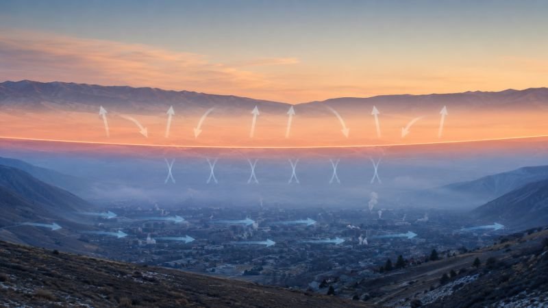
Temperature inversion is an atmospheric condition in which air temperature increases with height over a layer instead of decreasing, so the local gradient becomes dT/dz > 0. That reversed structure suppresses buoyant mixing because cooler dense air remains trapped below warmer air. The result is a stable stratified layer that can hold moisture, fog, smoke, or dust close to the ground.
In real landscapes, inversions form through nighttime radiative cooling, sinking air aloft, snow-covered surfaces, or valley topography that pools cold air. It is common in winter valley air pollution where weak mixing prevents dilution of fresh emissions. Used in devices include radiosondes, microwave radiometers, ceilometers, and distributed air-quality sensors that reveal how strongly pollutants are trapped near the surface.
The concept matters because inversion layers control pollutant dispersion, influence aviation visibility, alter frost risk, and change how meteorologists interpret near-surface weather. In environmental engineering and boundary-layer physics, recognizing an inversion helps explain why ordinary emissions can produce dangerous concentrations even when source strength has not increased very much. This makes exposure forecasting and emergency response far more difficult in dense urban basins.
Example:
A calm winter night in a valley can trap wood-smoke near the ground until daytime heating breaks the inversion layer.
Related Terms:
- Photochemical Smog
- Air Quality Index
- Atmospheric Stability
NoSuchDevice is a free archive of machines that do not exist yet but already have a shadow in physics. I research and write every entry alone, with no ads. Take a look around the archive, or help keep it free.