


What Is InSAR?
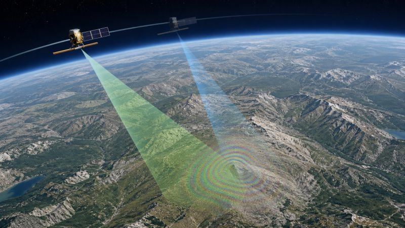
InSAR, short for Interferometric Synthetic Aperture Radar, is a radar technique that compares the phase of SAR measurements from different passes to estimate elevation or small surface motion. A common displacement relation is delta_d = lambda * delta_phase / (4 pi). Because phase is sensitive, motion of only millimeters can affect the result.
In real applications, InSAR works by aligning repeated radar images of the same area and analyzing how phase changes across time or viewing geometry. This makes it useful in surface deformation mapping, subsidence tracking, landslide monitoring, glacier motion studies, and earthquake analysis over very large regions.
The method matters because it can detect subtle ground change without dense sensor installation on the surface itself. Used in devices include orbital SAR missions, airborne radar campaigns, volcano observatories, infrastructure monitoring systems, and geodetic analysis pipelines that convert phase differences into deformation or topographic information.
Accuracy depends on orbital precision, coherence, atmosphere, and ground stability between passes. Engineers therefore correct for phase noise, terrain effects, and temporal decorrelation so the final signal represents real displacement rather than errors introduced by vegetation change, weather, or imperfect geometry.
Example:
Repeated radar passes can reveal gradual subsidence above a groundwater basin before surface cracking becomes obvious in the field.
Related Terms:
NoSuchDevice is a free archive of machines that do not exist yet but already have a shadow in physics. I research and write every entry alone, with no ads. Take a look around the archive, or help keep it free.