The monitoring station bolted to a traffic authority pole records whatever drifts its way at sensor height. At rush hour, the chemistry of the air three meters above the asphalt and the chemistry at sensor height are two different readings from the same event. One of them gets logged. The other one is what people are actually breathing. The station is not broken. It is simply in one place, and the city is in many places at once.
A device designed to address this would not be anchored to anything. It would fly through the air it measures, move where contamination moves, and stay up long enough for the data to mean something.
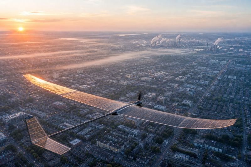
The short version: A solar-powered autonomous drone designed for air quality monitoring would fly continuously over cities, industrial corridors, and open water at altitudes between fifty and two hundred meters, drawing power from its own wing surface and carrying sensors for particulate matter, nitrogen dioxide, ozone, and volatile organic compounds (VOC). Operating in self-organizing swarms, a fleet of these drones could build a real-time three-dimensional map of atmospheric chemistry above any inhabited area. The physics permits it. The engineering gap between current components and the full device is genuine but not mysterious.
Key Takeaways
- Fixed monitoring stations produce point measurements; solar air quality drones produce spatial surveys – structurally different data, not just more of the same
- The device rests on one core tension: solar panels generate the power needed to fly, but they also add the weight that requires more power to fly
- A swarm coordinates without a permanent leader – the coordinating role floats between units as conditions change
- Night operation is the sharpest engineering constraint on the concept, and it resolves differently than most people assume
- The long-horizon form of this technology is not a drone fleet but a permanent atmospheric intelligence layer above every inhabited region of the planet
Table of Contents
The Measurement Gap That Fixed Sensors Cannot Close
There is something structurally odd about how humanity monitors the air it breathes. Decades of investment have produced networks of ground-based stations, each one a fixed point returning a single reading at a single location at whatever interval the operator programmed. The implicit assumption behind this architecture is that air quality within a given area is reasonably uniform, and a well-placed station can represent conditions across the surrounding neighborhood.
In flat terrain with slow winds and dispersed sources, that assumption holds adequately. In a dense city with complex traffic patterns, microclimates, and point-source industrial emissions, it fails in ways that matter to health policy.
One Station, One Point, One Version of the Air
A pollution plume from a warehouse loading dock two streets over may never reach the nearest monitoring station. The nitrogen dioxide spike above an intersection during peak traffic exists in a vertical and horizontal column that the station, positioned according to regulatory guidelines rather than real-time source tracking, may miss entirely. The resulting dataset describes average conditions across large zones, smoothing out the microclimatic events – the intense pollution spikes at schools, playgrounds, and residential streets near freight corridors – that carry the heaviest consequences for human health.
What the Satellite Cannot See From Up There
The remote sensing instruments used for environmental monitoring operate at the opposite extreme. Satellites see wide areas and long time periods, but their atmospheric resolution in the lower troposphere is limited. What looks like a clean urban signature from orbit can conceal acute localized events that a ground-level sensor, if it were in the right place, would catch immediately.
Satellites and ground stations together leave an unmapped middle layer: the first two hundred meters of atmosphere above populated areas, where most human-generated pollution originates and where most people spend their breathing lives. What fills that gap is a sensor that moves through it.
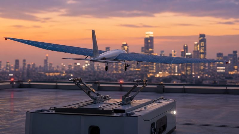
How a Solar Air Quality Drone Would Actually Operate
The concept is not a quadcopter with a solar panel strapped to the top. The geometry is different because the mission is different. Sustained horizontal flight over long periods favors a fixed-wing or hybrid configuration – wide, thin wings that generate lift efficiently and provide a large upper surface for solar collection without significant drag penalty. The aerodynamics and the power generation are part of the same structure.
The Operating Band – Fifty to Two Hundred Meters
Altitude is not incidental to this device. It is a design parameter. Below fifty meters, the drone encounters the turbulent wake of buildings, unpredictable crosswinds at street level, and the physical clutter of urban airspace. Above two hundred meters, the drone moves out of the pollution layer it is supposed to be sampling and begins measuring conditions that belong to regional meteorology, not urban air chemistry.
The band between fifty and two hundred meters is precisely where the device needs to operate. It is close enough to emission sources to resolve individual event signatures. It sits above most of the shadowing obstacles that make ground-level solar unreliable. And it provides enough vertical range for the drone to adjust altitude in real time toward whatever layer is currently most information-rich – dropping toward a traffic corridor at rush hour, climbing above a park where baseline readings are the goal.
Sensors, Weight, and the Payload Budget
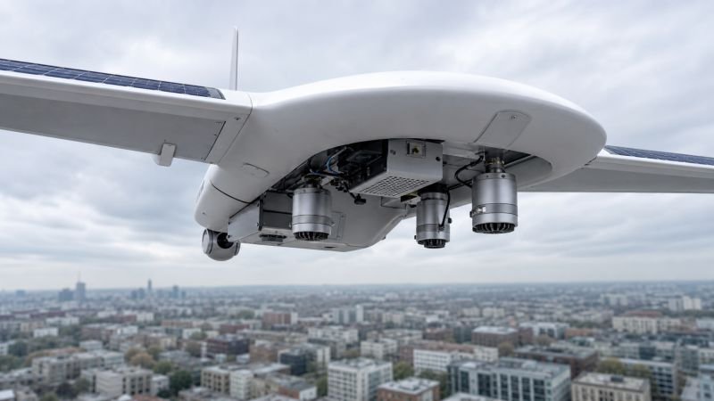
The sensor payload for this device draws on miniaturized technologies already demonstrated in laboratory and field conditions. Electrochemical sensors capable of detecting nitrogen dioxide, sulfur dioxide, carbon monoxide, and ozone exist in packages small enough for a drone in this weight class. Optical particle counters for PM2.5 and PM10 have been shrinking for years. Photoionization detectors for volatile organic compounds extend the detection range further.
The question is not which sensors are physically possible to include. The question is how many can coexist within a payload budget tight enough to leave margin for flight endurance. A well-engineered sensor suite for this device would need to come in under two hundred grams – a constraint that pushes toward continued miniaturization in Micro-Electro-Mechanical Systems (MEMS) sensor design, where mass and power draw are the primary variables being traded against sensitivity.
Calibration is a related problem. Electrochemical sensors drift over time. The swarm architecture handles this through continuous cross-referencing between adjacent units. If one drone’s readings diverge from its nearest neighbors measuring the same air mass, the swarm flags that unit for a recalibration cycle rather than logging the anomalous data as a real pollution event. The calibration reference is the network itself.
Solar Surface Against Gravity – The Core Engineering Tension
Every solar aircraft faces the same closed equation: the cells that generate power add weight that increases the power required to fly. Building this device is an exercise in finding a configuration where that equation produces a positive margin large enough to be practically useful, and then holding it there across changing conditions of sunlight, temperature, and payload.
The Power Budget
The photovoltaic effect places a ceiling on what any solar cell can extract from sunlight. That ceiling is set by the energy density of incoming solar radiation at the surface – approximately 1,000 watts per square meter under clear-sky conditions. How much of that becomes usable electricity depends on cell efficiency.
The formula governing the device’s power generation:
P_solar = A × I × η
Where:
- A = active solar collection area in square meters
- I = solar irradiance at the surface (approximately 1,000 W/m² under standard conditions)
- η = photovoltaic conversion efficiency
A drone with 3 m² of active solar surface operating at η = 0.35 (a conversion efficiency that thin-film multi-junction cell research places within achievable range, though not yet commercially standard) would generate:
P_solar = 3 × 1,000 × 0.35 = 1,050 W
Sustained fixed-wing flight for a drone in this weight class requires roughly 200 to 400 watts, depending on airspeed and atmospheric conditions. The power budget is positive. The margin exists. It evaporates, however, if the mass of the photovoltaic layer pushes the drone’s flight power demand upward fast enough to erase the surplus. Every gram of solar panel is a gram that requires more lift, which requires more power, which requires more panel area, which adds more grams. Breaking that feedback loop requires cells that are simultaneously lightweight, flexible enough to conform to a wing surface, and efficient enough to leave a meaningful margin above flight costs.
Where the Semiconductor Layer Needs to Go
The semiconductor architecture of the cells matters as much as their efficiency rating. The device described here assumes cells that can be applied as a thin, flexible layer over a composite wing surface without compromising the aerodynamic profile. Multi-junction designs that capture a broader portion of the solar spectrum, printed as a conformal coating onto the wing rather than mounted as rigid panels, represent the technology assumption the device rests on. None of that requires physics that does not exist. It requires engineering optimization that has not yet been done specifically for this application.
| Monitoring Platform | Spatial Resolution | Continuous Operation | Lower Atmosphere Access |
|---|---|---|---|
| Ground Station | Single fixed point | Permanent | Ground level only |
| Weather Balloon | Vertical column | Single pass | Full vertical range |
| Satellite | Regional (km scale) | Orbital pass | Surface inference only |
| Solar Air Quality Drone | Area survey (meters scale) | Indefinite (solar-dependent) | 50-200m optimal |
The table is not a competitive analysis. Each platform measures something different. What it shows is that the zone between ground level and satellite altitude – where most urban pollution lives – has no permanent resident sensor. This device would be the first.
Everything here is free. Readers are the reason it stays that way.
I make all of it alone, with no ads. If it is worth a coffee a month to you, that keeps the next one coming.
Keep it alive →After Sunset – Energy Storage and What Happens to the Swarm
The photovoltaic effect stops producing electricity when there is no light to convert. For a solar aircraft, this is not a minor operational detail – it is a fundamental boundary condition on the mission profile. Any honest description of this device has to address what happens when the sun goes down.
The most direct answer is energy storage: charge a battery during peak solar hours and draw on it overnight. The mass penalty of batteries sufficient for eight hours of continuous flight is real and measurable. Adding that mass increases the drone’s total weight, increases its power demand, and shortens the endurance the battery was supposed to provide. The feedback is familiar from the solar panel mass problem and it does not resolve more favorably here.
The more workable approach distributes the problem across time and across the swarm. During daylight hours the drone builds a stored energy surplus above flight requirements. At night it enters a reduced-power gliding mode – using thermal gradients and favorable wind patterns to maintain altitude with minimal propulsion, keeping sensor and communication systems active while waiting for dawn. Not full monitoring performance overnight, but enough presence to resume at first light without landing. Units whose battery reserves fall too low land on rooftop charging infrastructure and are replaced in the active layer by units that have rested and recharged.
The harder constraint is not nighttime but extended low-light conditions. Dense cloud cover, winter months at northern latitudes, and air so heavily particulate that solar transmission drops measurably all compress the daily energy budget in ways the device must accommodate. A city at high latitude in December receives a fraction of the solar irradiance that a subtropical port city sees year-round. Honest deployment of this technology accounts for that geography. The swarm over Helsinki in January would operate more conservatively than its counterpart over Lisbon in August – fewer units in continuous flight, more units cycling through rooftop charging, reduced coverage density during the darkest weeks. That is a design constraint, not a disqualifying flaw.
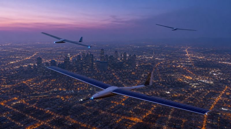
A Swarm That Picks Its Own Leader
A single drone measuring a city is an expensive curiosity. A hundred drones operating as an uncoordinated cloud produce overlapping data in some areas and blind spots in others. The concept only makes sense at scale – dozens or hundreds of units operating as a coherent sensing instrument distributed across space – and the question of how that coherence is organized matters as much as the hardware.
Leadership as a Temporary Function
Biological swarms do not carry a permanent command structure. The coordinating function emerges from local interactions between agents that each follow simple rules. The same logic applies here. In a swarm of air quality drones, the unit performing the coordinating role – managing coverage priorities, handling airspace conflicts between nearby units, redistributing the monitoring load when a member needs to land – holds that role temporarily. When the current coordinating unit falls below its operational threshold and needs to land, another unit with adequate battery reserves and communication reach picks up the function. The transition is a designed behavior, not a recovery event.
What makes this practical is that coordination in a distributed sensor network is a low-computation job. The coordinating unit does not need to track every drone in real time. It needs to know which coverage zones are undersupplied relative to current pollution density, and it needs to tell nearby units to move. Any unit in the swarm can perform that computation when required. There is no special hardware involved in being the leader – only a temporary assignment that rotates with operational state.
Coverage as an Emergent Property
The stronger design question is whether explicit coordination is even necessary, or whether good coverage can emerge from each drone following purely local rules about its immediate neighbors.

Each unit knows its own position and battery state. It can detect the positions of units within communication range. A rule as simple as “move toward zones with lower local drone density and higher recent pollution readings” produces adaptive spatial distribution without central command. The swarm concentrates where readings are changing fast and spreads out where the air is stable. A pollution event near a freight depot draws units toward it. Nobody programs that response directly. It follows from the local rule.
The practical value of this emergent behavior is resilience. A swarm depending on explicit top-down coordination fails when the coordinating unit fails. A swarm whose coverage pattern is a consequence of local interaction degrades gradually as units are removed, with no single point of failure capable of collapsing the network.
From City Blocks to Open Water – Where This Drone Would Fly
The urban use case is the obvious starting point. It is not the only one.
Cities, Industrial Zones, and Rooftop Infrastructure
In cities, the highest-value deployment zones are corridors where point-source emissions meet high population density: arterial roads with heavy freight traffic, construction sites producing silica and diesel particulate, industrial districts where stack emissions combine with street-level traffic chemistry. A drone that can descend to sixty meters over an intersection at rush hour and then climb to one hundred and fifty meters over residential blocks three streets away produces the spatial gradient data that current monitoring cannot generate.
Building rooftops become infrastructure in this picture – not obstacles, but platforms. A solar drone capable of identifying a clear rooftop surface and setting down for a brief recharging stop can treat the city’s existing building stock as a service network. No dedicated charging infrastructure required in the first deployment generation. The city’s own surface is the maintenance layer.
When the Air Gets Dangerous Fast
Forest fires produce air quality events that fixed stations cannot track. The fire moves, the wind shifts, and the pollution front is a three-dimensional structure in continuous motion. A swarm deployed ahead of a fire perimeter could track the particulate plume in real time, with coverage automatically redistributing toward the advancing edge as conditions change. Emergency responders and evacuation planners currently make these decisions with data resolution that is hours stale and kilometers coarse. A drone network changes that.
Industrial chemical releases present the same need: rapid three-dimensional mapping of a dispersing contamination event, achievable only with mobile sensors that can reposition in minutes.
The Ocean Has No Monitoring Stations
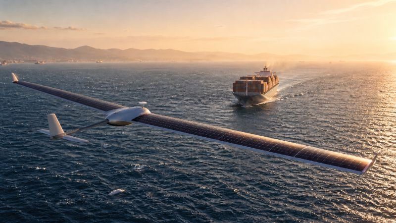
Maritime shipping produces substantial sulfur dioxide and particulate emissions, and the open ocean has essentially no air quality monitoring infrastructure. A drone designed for long-duration solar flight does not distinguish between flying over an urban grid and flying over the North Sea – the same aerodynamics apply, the same photovoltaics apply. Networks of solar drones operating over major shipping corridors would produce the first continuous atmospheric chemistry dataset for maritime environments. The implications for climate modeling and for coastal air quality in port cities downwind of busy shipping lanes are not minor.
What Future Developers Would Need to Solve
The physics behind this device is not in contention. What remains open is a set of engineering problems sitting between what component technology can currently do and what the full operational system requires.
The weight budget is the master constraint. Every design decision – cell efficiency, battery chemistry, sensor miniaturization, airframe materials – interacts with every other through total drone mass. Future developers would need to treat the system as a single closed equation. A change in any one component propagates through all the others, and optimizing subsystems in isolation produces systems that fail at integration.
Autonomous obstacle avoidance at operating altitudes is a solved problem in controlled environments and an incomplete one in cluttered urban airspace. The drone needs to respond to birds, cables, construction cranes, and turbulent building wakes at speeds where reaction time is measured in fractions of a second. This is primarily a sensor fusion and control software problem, which means the physics is not blocking it. The engineering is.
Long-term sensor calibration without external reference checks is another open question. The swarm’s internal cross-referencing can detect anomalous readings and flag units for inspection, but building algorithms that reliably distinguish a sensor fault from a genuine local pollution event that only one drone happens to be positioned to detect requires operational data that only accumulates once the network is actually flying.
The autonomous maintenance cycle deserves more attention than it typically receives. A drone requiring human intervention every time a sensor needs cleaning or a battery cell degrades is not a practical atmospheric network. The economic case for the system depends heavily on how much of the maintenance cycle the drones can perform autonomously at rooftop stations they access without human involvement. That is less a physics problem than a robotics and infrastructure problem – and solving it at scale has not been demonstrated.
Atmospheric conditions worth keeping in mind for developers: wind shear, precipitation, and heavily particulate air all reduce both flight stability and solar collection. These are manageable operational constraints, not barriers, but they belong in the design specification from the first day rather than appearing as field discoveries after deployment.
The View From NoSuchDevice
I find this concept sits at an interesting position on the speculative horizon – close enough to current engineering that calling it fantasy would be wrong, but far enough from mature deployment that calling it imminent would also be wrong. The seed form of this device is probably fifteen to thirty years from basic deployment. The version that actually matters – a permanent atmospheric sensing layer operating autonomously above every major city and shipping lane on the planet – belongs to a longer timeline, and those two things are worth keeping distinct.
The value is not proportional to technical proximity. A small pilot fleet of solar drones providing air quality data over one city is a useful data collection project. A global network of self-maintaining drones producing continuous three-dimensional air chemistry maps above all inhabited regions is something qualitatively different: an atmospheric intelligence infrastructure that changes what environmental policy, public health response, and climate modeling are physically capable of. The seed and the destination look superficially similar but are not the same technology.
The engineering problem I think is most underestimated is not the solar efficiency question, which the semiconductor science is already moving toward solving. It is not the swarm coordination question, which is tractable. It is the self-maintenance cycle – keeping thousands of small aircraft clean, calibrated, and airworthy for years with minimal human intervention across cities with different weather, different building stock, and different regulatory tolerance for autonomous aircraft on their rooftops. Every autonomous system eventually runs into the gap between what it can do in a controlled test environment and what the real world demands. That gap is where this device will be tested most seriously.
I also think the maritime application is more important than the urban one, and I suspect it will take longer to be taken seriously for exactly that reason. Nobody lives on the North Sea shipping lane. The political constituency for monitoring it is small. But the data it would produce about atmospheric chemistry over the world’s oceans – which cover most of the planet’s surface and are almost entirely unmeasured at low altitude – would matter for climate science in ways that urban monitoring, for all its obvious health value, is not.
The device makes sense. The physics is there. What the concept still needs is an operational context patient enough to wait out the engineering maturation cycle, which tends to be longer and less linear than early projections suggest.
You read the whole thing.
That is rarer than it should be, and it is the exact kind of attention I built this archive for. I make every piece alone, with no ads and no investor deciding what gets written. If you want the next machine taken apart like this one, you can help me make it.
A coffee a month is enough to keep it free for everyone.
Prefer crypto or a one time gift? Other ways to give →